|
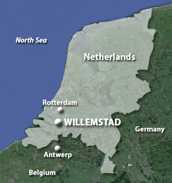
Willemstad
Noord-Brabant, Netherlands
|
|
 |
Constructed: 1583-1587
Used by: Netherlands,
France, Germany
Conflicts in which it participated:
French Revolutionary Wars, Second World War
|
Until the mid-16th century, the land where Willemstad stands today was a salt marsh. Salty or not, folks resided there as long as 6500 years ago. In 1968 an excavation in the town unearthed an oak figurine that dates to around 4500BC.
In 1565 earthen embankments were built at this location to create a dry spot big enough to construct the town of Ruigenhil, on the Hollands Diep (Hollands Deep) River. One wonders at the necessity of rescuing this specific spot from nature to build a town, but much of the Netherlands are below sea level, so it's not as though the locals could just go somewhere nearby for a decent patch of dry land. And this is a great spot.
|
|
 |
|
In 1477, Mary of Burgundy (1457-1482), ruler of the Low Countries, married Holy Roman Emperor Maximilian I (1459-1519). Thanks to the dazzling magic of royal dynasties, this set into motion the entity that would eventually become the Spanish Netherlands. It also set into motion the Eighty Years' War (1568-1648), also known as the Dutch War of Independence, when seven of the 17 Dutch provinces seceded from this silly Spanish-dominated nonsense to form the Dutch Republic, to which the Habsburg meanies of the Spanish Empire did not take kindly.
|
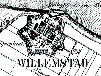
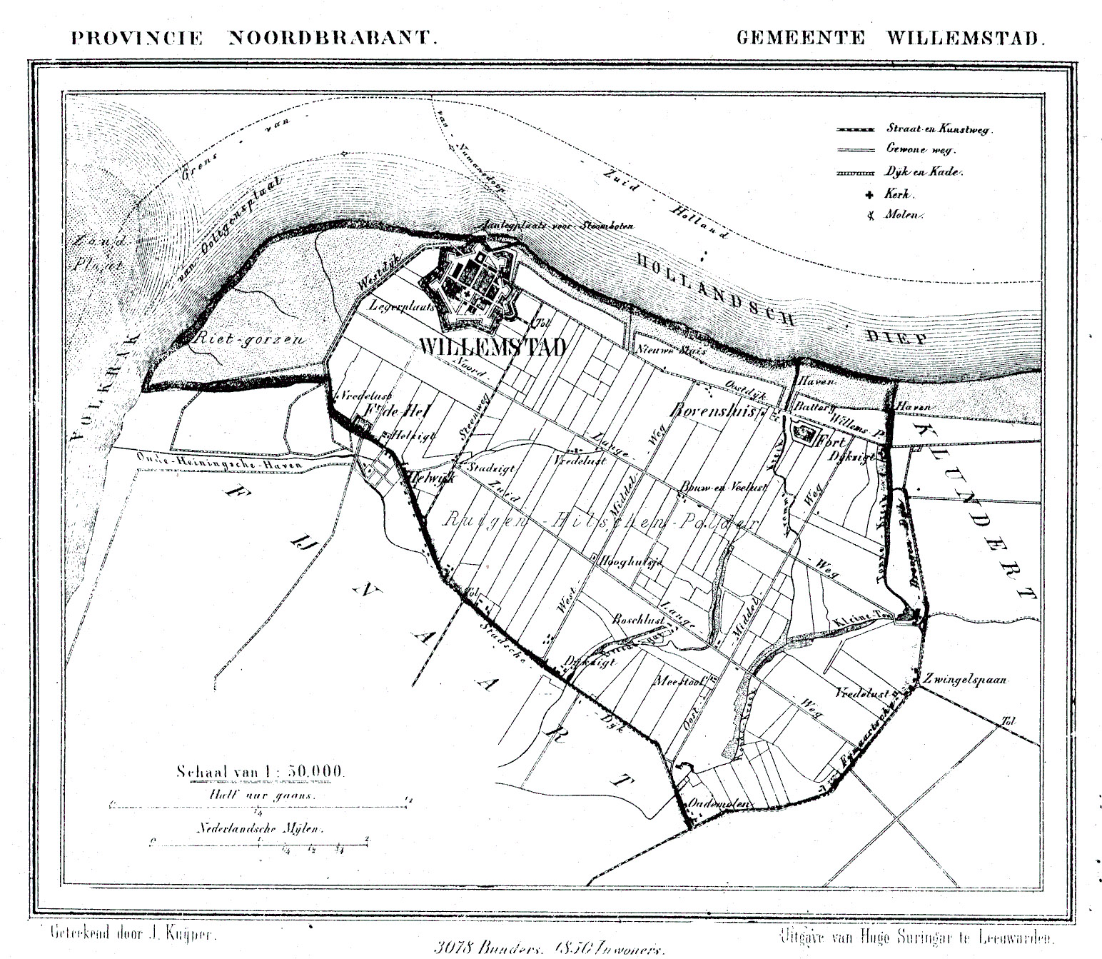
A city plan of Willemstad, 1865. Click on it to see the whole thing. |
|
At the Battle of Steenbergen (June 17, 1583), allied Dutch, French and English forces were swept away by the finely-tuned killing machine that were Spanish cavalry, artillery and infantry. Dutch Revolutionary leader William of Orange (1533-1584) (who was also known, much more pleasingly, as William the Taciturn) immediately thereafter ordered that the village of Ruigenhil be fortified. The year after William's death in 1584, the fortified town was rechristened Willemstad, or William's Town.
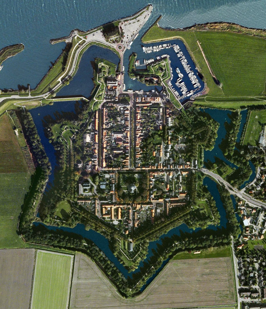
The initial fortification of Willemstad took the form of a five-pointed star, with two small forts inside. |
|
|
Military engineer Adriaen Anthonisz (1541-1620), who would eventually improve over 20 Dutch fortress/towns (including the eternally impressive Naarden), was called in to work his magic on Willemstad. The seven-pointed star that we see today is Anthonisz's work. Each of the city's seven bastions was named for one of the seven Dutch provinces that had rebelled against the Spanish crown, creating the Dutch Republic in 1568.
|
The first Protestant church in the Netherlands, the Koepelkerk, was built in Willemstad in 1607. William's son, Prince Maurits (1567-1625), permitted the construction of this church on the condition that it be round or octagonal in shape (?!). Which it is, but don't ask me why that would be important.
On February 1, 1793, Revolutionary France declared war against "the tyrants George III (of England) (1738-1820) and William V (of the Netherlands) (1748-1806)." Thereafter followed an orgy of French "annexation" of much of the Netherlands, which included a siege of Willemstad by French forces. Willemstad held out for a period of time that doesn't seem to be available to me, but surrendered when the nearby fortified town of Bergen op Zoom fell to the French.
|
|
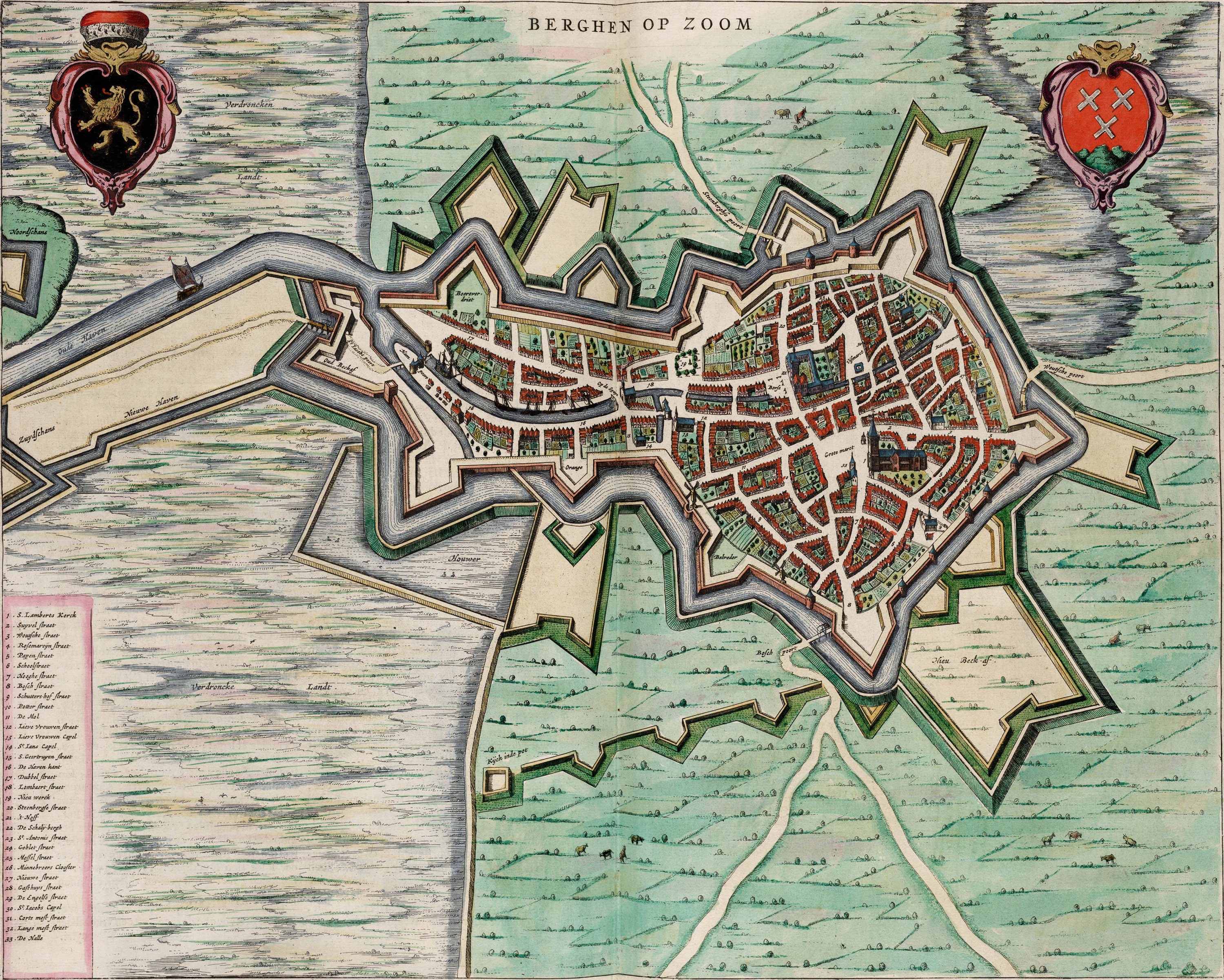
 The Dutch city of Bergen op Zoom, as it appeared at the height of its pointy powers in 1652. This stellar fortified city has little to do with Willemstad, but this map is so pretty I had no choice but to stick it here. Click on it, it's huge. The Dutch city of Bergen op Zoom, as it appeared at the height of its pointy powers in 1652. This stellar fortified city has little to do with Willemstad, but this map is so pretty I had no choice but to stick it here. Click on it, it's huge. |
|
On July 30, 1809, nearly 40,000 British troops landed on the Dutch mainland at Walcheren, in the interest of opening another front against Napoleon (1769-1821) and thus easing pressure on Britain's allies, the Austrians, who were getting their tuckuses whupped. Though this expedition was unsuccessful, in that the British Army lost 4,000 men to "Walcheren Fever" (thought to be a combination of malaria and typhus), managed to engage the French in very little combat and withdrew in December of that year, the Walcherin Campaign did manage to worry Napoleon enough to visit Willemstad in 1811.
|
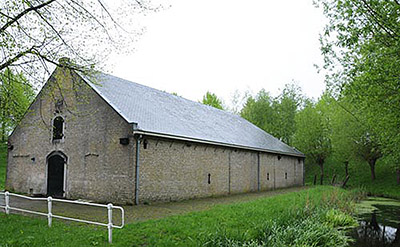 Willemstad's powder magazine, built in 1811 at the behest of our good friend Napoleon. Willemstad's powder magazine, built in 1811 at the behest of our good friend Napoleon. |
|
During his visit, Napoleon said, "Y'know what this place needs? A powder magazine!" A powder magazine was duly built as per his wishes, as well as two small coastal forts to the south of Willemstad, Fort Sabina Henrica and Fort Hell.
In 1874, Willemstad became an important part of the Theorem of the Hollands Diep and the Volkerak. This was a defensive line that ran along the south bank of the Hollands Diep and Volkerak Rivers, intended to prevent an attack into southern Holland, and/or to defend retreating troops. The Theorem was part of a nationwide defensive plan called the Vestingwet. |
|
|
The Vestingwet came about as a result of observation of the recent Franco-Prussian War (1871): Defense in depth was realized to be of greater importance in an era of long-range artillery. As opposed to depending on individual fortifications to defend a city or other strategic area, a series of forts were needed, each capable of defending not only its immediate surroundings but also its closest neighbor fort, through the application of accurate long-range artillery fire. This perfectly reasonable theory led to the concept of the artillery fort, which were little fortlets that were built in the last decades of the 19th century in Europe: The cities of Utrecht and Strasbourg, for example, are both surrounded by up to sixteen such forts.
|
Unfortunately, the Vestingwet also caused the destruction of a number of the Netherlands' precious starry fortifications around several of their cities, as such defenses were considered superfluous under the new system. The cities involved, such as Gronigen and Nijmegen, were pleased as they were able to expand once these centuries-old masses of masonry were removed. The Vestingwet continued in all seriousness until 1938, during which time the Netherlands were not attacked by anyone, so...perhaps it worked?
What did not work, however, was the small Dutch garrison of Willemstad at the very start of the Second World War (1939-1945).
|
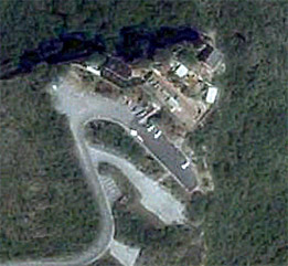
|
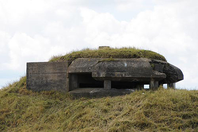
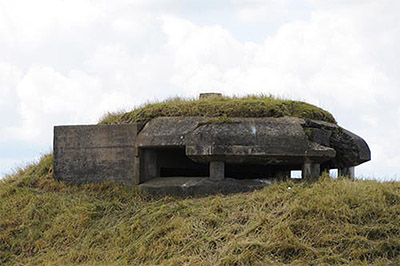 A German observation bunker, added to Willemstad under German occupation during the Second World War. Germany built two such observation bunkers, four anti-aircraft batteries and anti-tank defenses to Willemstad during this period. |
|
Germany invaded the Netherlands on May 10, 1940. Four days later, a reconnaissance detachment of German troops in armored cars drove into Willemstad and, after "a brief skirmish," the defense was abandoned and the fortified city belonged to Germany. The Nazis built a series of bunkers and anti-aircraft batteries within the city's walls, which were manned by a small garrison. The Nazis were chased out of the Netherlands by Canadian, British and Polish troops in 1944-45.
The "fortress" portion of Willemstad (which is all of Willemstad) was abolished by royal decree in 1926. Fortunately, nobody got around to demolishing anything before the fortress was declared a conservation area in 1970.
|
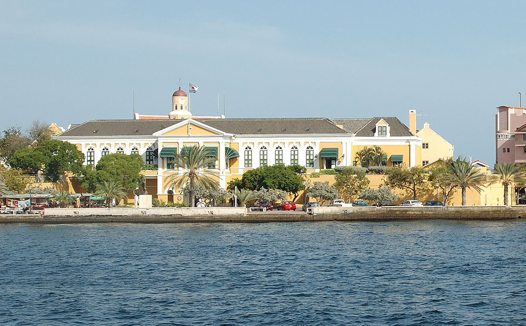
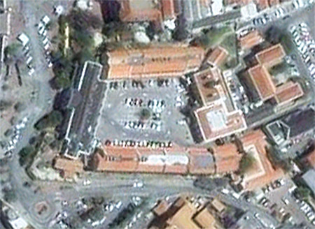 Fort Amsterdam, Willemstad, Curaçao. Trust me, that's a starfort. Fort Amsterdam, Willemstad, Curaçao. Trust me, that's a starfort. |
|
Making my life difficult when researching Willemstad was the fact that there's another Willemstad, with a starfort, on the Caribbean island of Curaçao.
In 1499, the Spanish discovered Curaçao. By 1527 they had taken away almost all of the native Arawak people to Spain as slaves, rendering the island acceptable for proper Spanish settlement.
The Dutch West India Company (GWIC) captured Curaçao from the Spanish in 1634. |
|
|
The Dutch named their new city Willemstad, after William II of Orange (1626-1650), a royal prince and "Stadtholder," which was some sort of medieval royal position that I won't even pretend to understand.
|
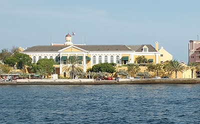
Fort Amsterdam was built from 1635 to 1636, under the direction of Admiral Johannes van Walbeeck (1602-1649), a cartographer and navigator in the employ of the GWIC. The fort was intended to serve not only as a defense for the city's harbor, but as a base of operations for the GWIC in Curaçao.
Life was fairly peaceful at Fort Amsterdam until June of 1929, when Venezuelan revolutionary Rafael Simón Urbina, with 250 men, captured the fort. They plundered guns, ammunition and the island's treasury, then kidnapped the Dutch governor of Curaçao, Leonardus Albert Fruytier, and dragged him back to Venezuela in a captured American ship. Exciting!
|
|
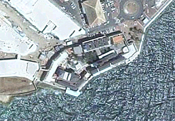
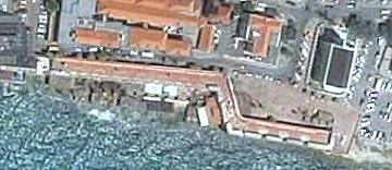
 Fort Amsterdam is one of the very few starforts that look better at ground level then they do from above. |
|
The Netherlands Antilles were finally dissolved in 2010, whereupon Curaçao became "a country within the Kingdom of the Netherlands," free to do just about anything other than defend itself or conduct foreign policy. Sweet gig.
Three other Dutch forts at Willemstad, Curaçao:
 Waterfort Waterfort
Many thanks to fellow starfort enthusiast Werner Hack, who alerted me to the fortified city of Willemstad!
|
|
|
|
|
|
|